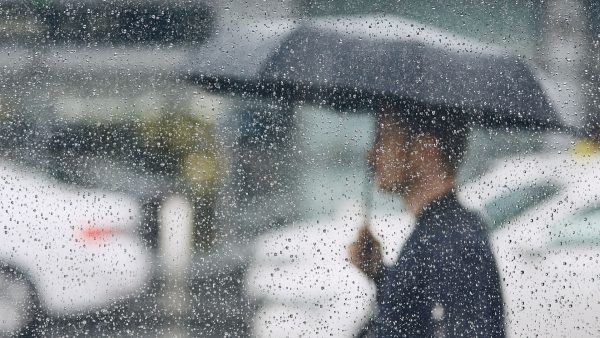
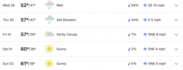
After a cold and wet Christmas, more rain and snow fell in the Southland, with additional precipitation in the forecast through New Year’s Eve, save for a brief respite Tuesday.
A winter storm warning will be in effect until 10 p.m. in the Los Angeles County mountains, excluding the Santa Monica range. According to the National Weather Service, between 5 and 10 inches of snow could accumulate at elevations above 5,000 feet, and 2 to 4 inches above 4,000 feet.
The snow level will drop later in the day, with “a couple inches of snow accumulation possible along Interstate 5 near the Grapevine.”
“A wet and unsettled weather pattern will continue through Thursday,” according to the NWS. “Rain and mountain snow will taper off this evening but return again Wednesday and Thursday. Temperatures will remain significantly below average for this time of year with cold overnight temperatures expected away from the coast. Dry weather is expected Friday through the upcoming holiday weekend.”
A wind advisory will be in effect in the Antelope Valley until 10 p.m., with forecasters predicting winds of 25 to 30 mph, and gusts up to 50 mph.
Some parts of the Southland, meanwhile, will be dealing with particularly cold weather, with a frost advisory in effect to 8 a.m. Tuesday in the Santa Clarita and San Fernando Valleys and the Santa Monica Mountains Recreational Area. According to the NWS, temperatures as low as 32 degrees are expected, with “isolated pockets” of temperatures near 30. The frost “can damage sensitive plants and harm pets if left unprotected,” according to the NWS.
After a respite Tuesday, a stronger storm system is expected to arrive on Wednesday, but rainfall amounts are still uncertain, according to the NWS.
“Rain should start to move in on Wednesday or Wednesday night, and depending upon the exact track of the storm system, this could end up being a significant storm system for the region,” forecasters said.
That system is expected to continue into Thursday, possibly into Friday, bringing more snow to mountain areas, and “possibly bringing accumulating snowfall to the Antelope Valley.”
New Year’s Day was shaping up to be dry but cool across the region.
[…] Source link […]