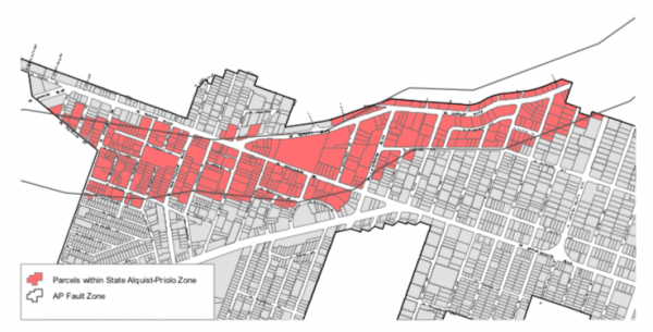
A recent revision to the state’s earthquake fault map has added 146 lots (covering a total of 43 acres) to the Hollywood Earthquake Fault zone in West Hollywood. That means a developer proposing a new development on any of those lots must conduct a complex and expensive “fault rupture investigation” to ensure that the project won’t be within 50 feet of an actual fault.
That investigation involves digging deep trenches to locate the fault and determine whether it has been active within the last 11,000 years.
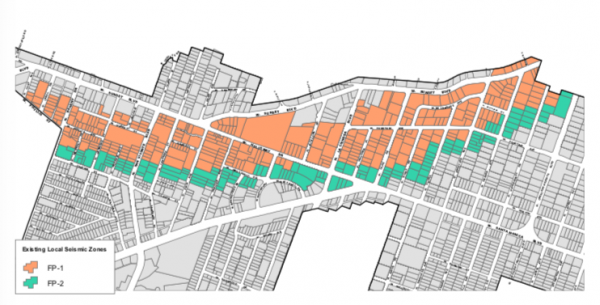
The 9.3-mile Hollywood Earthquake Fault runs from West Hollywood east to Atwater. In 2001, the City of West Hollywood identified two zones around the fault for which special rules were put in place for new development. Fault protection zone 1 includes land where an active fault is likely, and thus developers of new projects must conduct the fault rupture investigation. Fault protection zone 2 is an area less likely to contain a fault. Rather than conduct a fault rupture investigation in zone 2, a developer can reinforce a building’s foundation to protect it from an earthquake shake.
The revised state map places lots on the north side of Sunset Boulevard from Londonderry Place on the west to Sweetzer Avenue on the east in the “fault rupture investigation” zone. Further west, the revised state map now includes lots on the south side of Sunset between Hammond Street and San Vicente Boulevard.
In the Norma Triangle neighborhood, the state map also extends the FP1 zone over Cynthia Avenue, adding the area bordered on the south by West Vista Grande Street, on the west by Doheny Drive and on the east by North Hilldale Avenue.
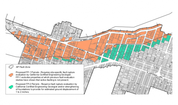
The revised state map has removed 42 lots from the city’s current FP1 zone. They include most of those on the existing city map that are south of Fountain Avenue from Hacienda Place west to Harper Avenue. Also removed from the state map are many of the lots north of Fountain Avenue from Harper to Crescent Heights Boulevard.
The city’s Planning Commission on Nov. 21 will be asked to consider a proposal from the Planning and Urban Development Services Department that those proposing to develop new buildings on lots moved out of the FP1 zone on the state map or to build on the current FP2 zone lots be required to either conduct a fault rupture investigation or provide reinforced foundations.
Under the state’s Alquist Priolo Earthquake Fault Zoning Act, the California Geological Survey agency is required to compile detailed maps of the surface traces of known active faults, which are updated from time to time. Owners of property in fault zones must disclose that to prospective buyers, however, they are not required to make that disclosure to renters.
The Planning Commission will consider the staff proposal at its meeting on Nov. 21 at 6:30 p.m. in the City Council Chambers, 625 N. San Vicente Blvd. Parking is free in the adjacent parking structure with a ticket validated in the lobby.
The challenge will be how to create safe guards to insure the developer’s fault study is in fact accurate. This is very akin to how traffic studies are conducted and experience has demonstrated that these studies have a disheartening range of “accuracy”. Perhaps the consultants need to be hired off a State approved list to insure that studies are conducted in a scientifically honest manner. If we have a fault study that compares to the self serving and incompetent environmental impact report for the Bond Hotel project, then we are in big trouble.
It seems a smoke screen to take the warning off areas and parcels the Big Developers controlling weho that they want to build and build BIG with no worry or cost.
It seems the new areas and lots contain properties that are smaller residential or just not suit for building.
I thought faults were billions of years old.
In weho they radically pick up and move, coincidentally making new Big Projects possible.
Who knew in 5-8 years, our fault map has flipped in two areas.
Dangerous, now safe
Safe (and not desirable for new building) now in danger zone.
Hmmmm
Please Post Bigger Maps. Can’t Read.
To date we have been unable to find them, but we are still looking
Maps are available for viewing at the CGS Information Warehouse: https://maps.conservation.ca.gov/cgs/informationwarehouse/
Zoom to your location, click on the map, and download the “Zone of Required Investigation PDF map.
Not sure what the differences are, but this is the link I found of CGS Earthquake Zones: https://maps.conservation.ca.gov/cgs/EQZApp/
Could Wehoville please print more distinct versions of these maps or links to them.
Thank you.
To date we have been unable to find them, but we are still looking
I do believe this will effect the proposed building on Larrabee at sunset. I noticed this when I made my comments regarding the environmental survey. I’m curious to see if the city takes this into account
It would be nice to have links to the actual maps so we could read them more easily.
They literally just put up or are putting up tall projects in this new ‘zone.’ Why couldn’t this have come earlier, so some of those ugly Sunset near La Cienega buildings could have not gone up. #toolittletoolate
I think those at Sunset/La Cienega area were all part off the then-Sunset Millennium Project that, I believe, did do the above mentioned fault rupture investigations involving the deep trench drilling to ensure they were 50 feet from any active faults.
The tall buildings are actually one of the most safe places to be in an event like this. Especially the modern ones. They are usually built on rollers.
It’s a good thing all of Sunset got built to the gills already. Developers will have to make a lot of political contributions if the Council accepts this.